09 January 2026
Key Takeaways
-
Conventional inspections overlook scale and detail on large Alberta sites and bog down decision-making. Drones offer high-resolution aerial perspectives that enhance precision and efficiency throughout planning, monitoring, and reporting.
-
Take scheduled drone flights to monitor progress, planned versus actual work performed and milestones. Develop timelines and monthly reports to keep everyone on board.
-
Perform remote inspections of inaccessible locations to lower risk and expense. Equip drones with zoom and sensors for close-ups and keep safety logs for audits and compliance.
-
Combine RTK drones and photogrammetry to generate accurate 3D models, orthomosaics, and volumetric measurements. Use these in earthworks, stockpile, and large-site surveys in all industries.
-
Get stakeholder-ready with professional aerial photos and concise abstracts. Secure online galleries increase transparency, trust, and faster approvals.
-
Be regulatorily responsible, hire licensed pilots, schedule safe flight paths and coordinate with authorities if necessary. Choose seasoned vendors, like Andrew Shaw Photography, for reliable, top-notch outcomes throughout Alberta.
Drone photography Alberta means shooting stills and video using UAVs around Alberta’s urban centers, parks, and countryside. The selection covers Calgary and Edmonton’s cityscapes, Drumheller badlands, and mountain vistas of Banff and Jasper. Bright light, long summer days, and wide open prairie skies contribute to generating crisp shots and crisp shadows. Rules matter: pilots follow Transport Canada’s Part IX, keep below 120 m, avoid crowds, and need permits in national parks. Local weather changes quickly, so wind checks and battery strategies minimize danger. Typical equipment consists of 1″ sensor drones, ND filters, and high-bitrate 4K. Next, discover zone-specific rules, optimal times, site recommendations, equipment advice, and example flight plans.
Traditional Construction Oversight
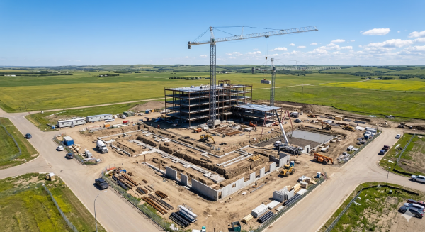
Traditional oversight relies on boots on the ground, hand-written notes and static images. It’s fine for little projects, but Alberta’s big sites and race-paced build cycles make those gaps pop in a hurry.
On the ground, teams walk large perimeters, climb scaffolds, and take measurements manually. This requires hours, sometimes days, and frequently involves road closures, lifts or safety spotters. When crews need to access difficult-to-access areas, such as bridge undersides, roof edges, and tall formwork, the danger increases. Delays accumulate when weather sours or access is obstructed by live construction. In the remote parts of Alberta, long drives add additional hours and expenses prior to any data being recorded.
Photos from the ground miss scale. A lens from the road won’t spot subgrade alignment on a 3 km corridor, rebar placement across a large deck, or stockpile volumes on a spread-out yard. Challenging sites, such as high-rises, wind farms, and pipelines, require views from multiple elevations and perspectives to identify conflicts, settlement, or safety risks. Using just 2D drawings and manual measurements, teams use tape, wheels, or rangefinders that can drift by centimeters. Little mistakes turn into giant change orders when you multiply them over concrete, trench, or facade runs.
Manual inspections can miss early defects. Hairline cracks, post-rain ponding on flat roofs, or misaligned anchor bolts may not be apparent from the ground. By the time someone comes back with a lift or a second crew, concrete has cured, steel is up, and fixes cost more. Data collection and review remain slow, as notes, photos, and sketches must be sorted, named, and hand-entered into reports, which increases error and delays updates by days.
Stakeholder communication relies on static PDFs and low-resolution images. These seldom respond to easy inquiries such as ‘Where precisely was this taken?’ or ‘How did this vary week to week?’ Without site-wide context, owners, lenders, and regulators have to guess or ask for another visit.
|
Aspect |
Traditional Methods |
Drone Photography |
|---|---|---|
|
Coverage |
Limited, line-of-sight |
Wide-area, aerial context |
|
Speed |
Slow, labor-heavy |
Fast capture, repeatable |
|
Safety |
High exposure |
Remote, lower risk |
|
Accuracy |
2D, manual errors |
High-res, precise geo-tags |
|
Reporting |
Static, delayed |
Visual, near real-time |
How Drone Photography Revolutionizes Construction
Drone photography provides actionable aerial perspectives, efficient site inspections, and accurate documentation teams can leverage throughout the project lifecycle. High-resolution stills, 360-degree photos, and stable video assist in monitoring work, identifying problems quickly, and communicating progress with stakeholders. It’s safer and more cost effective than many ground or helicopter techniques.
1. Progress Tracking
Regular flights at regular intervals grab the same vantage points week after week. Crews record start to finish change with high-def before and after photos and quick clips that demonstrate progress at each stage.
Visual timelines and monthly site reports keep schedules honest. Managers cross-check planned versus actual layouts and elevations and flag delays early instead of once rework piles up.
360-degree photos mean no corner is out of frame, which makes documentation for compliance simpler. These logs help closeout packages and warranty handovers remain comprehensive.
2. Site Inspections
Remote drone inspections go to roofs, façades, towers and steep grades without scaffolds or lift rentals. That reduces danger and lets trades continue working underneath.
Zoom cameras and optical sensors detect cracks, loose panels or misaligned brackets, all from a safe standoff distance. Teams eschew helicopter rides to make regular inspections. Documented passes bolster safety by recording hazards such as open edges, absent guardrails or blocked access ways.
3. Data Collection
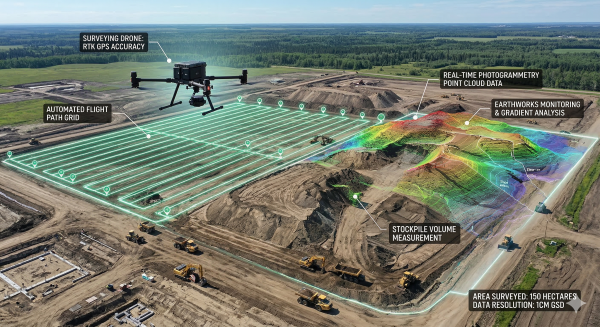
Drones take care of the precision work on huge parcels such as topographic surveys, orthomosaic imaging, and orthographic mapping that feeds back cut and fill data in real time with incredible accuracy.
Using RTK drones and photogrammetry software, teams generate 3D models, surfaces, and measurement reports. GIS integration creates entire 3D scenes for clash reviews and design updates.
Volumetric data of earthworks and stockpiles backs pay apps and haul plans. Solar farms, environmental projects and transport sites receive quicker baselines and fewer field hours.
4. Safety Compliance
Aerial photos document safety plans, site layouts, and traffic patterns for audits. Regular flights monitor perimeter fences, utility lines, and clear emergency access routes. Live video at the scene directs action and captures compliance trails.
5. Stakeholder Reports
Investors and owners receive bite-sized monthly progress reports complete with milestone and phase high-resolution images. Online galleries provide safe instant access.
Trust-enhancing clear aerials cut meeting time. Expert pilots and flight planning apps make sure the capture is efficient, with time and cost savings accumulating across the schedule. Remote monitoring hones coordination and keeps teams on the same page from anywhere.
Navigating Alberta's Airspace
Drone pics in Alberta fall under Transport Canada’s regulations, along with local regulations on privacy, trespass, and safety. What you’re allowed to do depends on your drone’s weight, safety tech, how close you are to people, and where you fly in relation to airports, heliports, and critical sites. The majority of flights are under Canadian Aviation Regulations (CARs). Certain work requires a Special Flight Operations Certificate (SFOC). Fines for breaches can be as much as CAD 25,000, and jail is a possibility for serious cases.
-
Confirm the drone class and weight, as well as the pilot certificate needed, whether Basic or Advanced.
-
Review NOTAMs and the CFS for adjacent aerodromes.
-
Check NAV CANADA airspace maps and altitude restrictions. Stay below 120 m AGL unless approved.
-
Keep laterally clear of individuals and property according to CARs and drone class.
-
Additionally, do not enter controlled or restricted zones, critical infrastructure, or emergency scenes without authorization.
-
Submit NAV CANADA requests or SFOC applications when required. Secure takeoff and landing sites.
-
Log flight plans, maintenance, and incident reports. Carry your certificate, registration, and insurance.
-
Respect privacy: do not record private spaces. Get consent for identifiable subjects.
Plan safe flight paths with geofenced waypoints that skirt airports at Calgary and Edmonton, small aerodromes and heliports common near hospitals or oil and gas sites. Cross-reference airspaces with legal land descriptions to verify surface access rights and obtain park or Crown land permits as necessary. Maintain buffers from neighboring properties to minimize noise and privacy issues and select launch locations to prevent trespassing. For a farm shoot near Red Deer, carve out a corridor outside controlled airspace, maintain 30 to 50 meters lateral separation from workers and obtain written permission from landowners in the line of sight.
Contract professional, licensed drone pilots and have proof readily available. Every pilot must carry a valid drone pilot certificate during operations. Only fly near people or controlled airspace with advanced-certified pilots and have registration labels correspond to the aircraft being flown. Even for hobby flights under 35 kg, you must still comply with the Aviation Act and CARs, even if not doing paid work. Maintain aircraft logs and preflight checklists consistent across crews.
Coordinate early for SFOCs when work falls outside standard rules, such as beyond visual line of sight, higher altitudes, night shoots without compliant lighting, or operations close to crowds. For large film units in Banff’s edge or industrial zones, align with Transport Canada, NAV CANADA, and land managers. Build a timeline for risk assessments, site permissions, and emergency plans.
Beyond Blueprints and Beams
Drone photography in Alberta is about more than logging progress. It opens visionary new avenues for marketing, brand lift and investor trust while satisfying documentation requirements.
Marketing
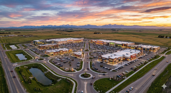
High-impact aerial photos and short clips capture full sites in a flash, from rooflines to parking flow. A 15-second orbit can show scale, sightlines and sun paths. A 30-second reel couples sweeping pans with intimate fly-throughs. For big mixed-use projects, overhead images plot access, transit connections and adjacent parks.
MLS listings win with sharp, high-resolution shots that capture lot shape, setbacks and views that ground photos don’t. Corporate sites have hero aerials on landing pages and maps that have callouts for amenities within 500 to 1,000 meters. Social posts include fast edits formatted for 1080 by 1920 vertical.
Buyers and investors react to angles they don’t receive from street level. Aerials put listings in perspective, bringing them to life and making them relatable. They illustrate, for example, how a condo faces the river or how a warehouse connects with major arteries. This reduces time and site visits by providing a complete perspective in minutes.
Teams can ship ready media in 12 to 24 hours: edited photos, captioned clips, and color-matched stock of skies and context scenes. From brochures and billboards to programmatic ads and launch pages, packages provide consistent tone and framing.
Storytelling
A mash-up of drone and ground images can follow a project from grade to handover, connecting milestones to a defined narrative.
Time-lapse flights from fixed waypoints reveal change week by week. Viewers experience land shape, foundation pours, crane moves, and facade close, which builds confidence and minimizes update calls.
Cinematic moves, slow tilts, parallax passes, and low sweeps inject polish at no significant expense. ‘Smart angles’ highlight design decisions, such as green roofs or storm water features that indicate thoughtfulness.
For Alberta work, show the setting and impact: prairie edges, river bends, foothills, or dense urban grids. This anchors the brand’s vision with location, meaning, and sustainable worth.
Bidding
Bids get heft with annotated aerials, 3D fly-throughs and easy web viewers that allow teams to pan, zoom and tag risks. One pass can capture a complex site in approximately 15 seconds, after which orthomosaics provide the basis for area checks, haul routes and laydown zones.
High‑res overviews for takeoffs and staging, quick measure tools to help test crane swing or buffer lines. This planning proof demonstrates viability, reduces speculation, and provides a crisp advantage in close contests.
Choosing a Professional Pilot
Selecting a pro pilot for Alberta drone photography requires obvious experience, licensing, safety, and actual results. The goal is simple: get reliable flights, clean data, and sharp images that meet your brief.
Select a drone photographer with proven experience in construction projects and commercial drone operations.
Seek out pilots who have flown on live sites, collaborated with site managers, and provided deliverables of repeatable mapping or progress shots. Request work samples such as weekly facade inspections, earthwork volume surveys, or crane-height rooftop scans. Make sure they can schedule flights considering site hours, weather fluctuations, and no-fly zones without postponements. Confirm they have flown 100 to 200 hours on commercial jobs, can execute steady capture plans at predefined altitudes, such as 60 to 120 meters, for consistent image scale. Versatility matters too; show they can handle stills, video, orthomosaics, and low-light scenes at dawn when crews are off-site.
Verify the pilot holds a valid drone pilot certificate and complies with all aviation safety protocols.
Professional pilot should possess a certificate obtained following mandatory training and an online test. Certificates are tiered, including basic, advanced, and Level 1 Complex operations, each with varying regulations on where you can fly. For Level 1 Complex, a pilot has to clear an online exam, complete a minimum of 20 hours of ground school, and pass a flight review. Request evidence of the certificate, date of issue, and insurance. Verify your understanding of airspace regulations, altitude restrictions like flying above 120 meters (400 feet), and any localized constraints. For professional work, inquire when they last did a flight review and what emergency protocols they pursue for GPS loss, battery failures, or wind gusts.
Assess the provider’s portfolio for quality, consistency, and a range of aerial photography types.
Browse entire galleries, not highlight reels. Seek out even exposure, clean horizons, and sharp focus from edge to edge. Test sets in different seasons, mid-day glare, and low-sun contrast. Check deliverables such as 4K or 6K video, 20 to 45 MP stills, RAW files, orthomosaics with specified ground sampling distance, and transparent file naming. Prove expertise with multiple drones and cameras and sensors if required. Request customer references related to the specific work you require.
Choose Andrew Shaw Photography for exceptional client satisfaction, personalized attention, and high-resolution results across Alberta, including Edmonton and Calgary.
Think quickscoping, site-ready flight plans and constant communication from preflight to delivery. Client work involves high-res stills, stabilized video and mapped sets for constructions and real estate. Servicing all major centers and backroad drives with transparent rates and turnaround times.
The Future of Aerial Views
Alberta’s drone photography is rapidly advancing, propelled by the demand for transparent information, time constraints, and pristine imagery that resonates across groups. Cost-effective, fast-deployment, and scalable, it is fit for urban sites, remote oil and gas corridors, resorts, farms, and mountain parks. It spans stills, video, and interactive aerial panoramas and is much more than a camera on a gimbal. It is a complete workflow combining flight plans, sensors, and post-process tools.
Anticipate advancements in drone technology, such as multispectral sensors and AI-driven analytics, for even greater project insights.
New payloads add more than RGB. Multispectral and thermal sensors identify heat loss on roofs, map crop vigor, and identify moisture hazards on new roads. LiDAR provides dense point clouds beneath trees to manage volumes and cut fill with errors under a few centimeters. AI will sort frames, pull out defects, and tag assets. Anticipate intelligent flight modes that compensate for wind, maintain ground sample distance around 1 to 3 centimeters, and stream live metrics to dashboards. Flight planning apps such as DJI GS Pro and Pix4Dcapture already script repeat paths and heights, so teams have baseline to baseline comparables over months.
Expect increased integration of drone surveying services and 3D mapping in construction workflows.
To Alberta builds, weekly orthomosaics and 3D meshes slot into BIM and GIS. Crews employ them to inspect rebar, trench lines, stockpile volumes, and crane paths. Progress maps connected to schedules reduce site walks and rework. Early or late flights provide soft warm light that texturizes the aggregates and concrete joints. Safety and professionalism stay core: certified operators, airspace checks, and documented gear reduce risk and keep projects on time.
Recognize the growing demand for cinematic drone videography and virtual tours in marketing and project documentation.
Aerial views peddle the macro. Homes with aerial shots sell 68% faster than ground-only listing photos, and the same logic applies to resorts, campuses and master-planned sites. Smooth 4K video, 360 clips and VR tours enable buyers and stakeholders from around the world to scan views, access roads and site edges in minutes. Short reels for socials, long cuts for investor decks and interactive links for RFPs make content useful beyond a single campaign.
Encourage developers and contractors to leverage professional drone photography services like Andrew Shaw Photography to stay ahead in Alberta’s evolving construction landscape.
To support this ambition, specialist teams deploy the appropriate sensor, plan, and permits for each job, be it a dense urban infill or a wind farm stretched across tens of kilometers. Rew Shaw Photography pairs strict safety with clear deliverables: calibrated stills, stitched maps, VR-ready tours, and edit-ready video. The outcome is quicker intelligence, improved bids, and clearer stakeholder reports.
Conclusion
Drone work in Alberta provides obvious benefits on construction locations. Teams observe more, navigate quickly and minimize danger. Grade, stock and site flow is shown in photos and maps. Quick flights follow pour lines, roof work and road ties. Crews identify gaps before they become expensive.
Rules in Alberta keep out of the way. Air maps, line of sight, and pilot certifications keep flights safe. The pro pilot is familiar with the no-fly zones around towns, farms, and rigs. That translates into crisp images and no penalties.
To schedule next steps, designate one pilot brief. Select a site activity. For instance, take measurements of a soil pile, digitize a trench, or map a haul road. Go over the file with the gang. Remember the time saved and the mistakes captured. Need assistance plotting that initial journey? Contact me to schedule a brief consultation.
Frequently Asked Questions
What are the main benefits of drone photography for Alberta construction sites?
Drone photos provide rapid, precise site intelligence. They eliminate manual inspections, increase safety, and reduce costs. Teams receive updated visuals, volume calculations, and status reports. This improves decisions and timelines.
Is drone flying legal over Alberta construction projects?
Yep, with the appropriate approvals. Pilots have to comply with Transport Canada rules, airspace restrictions, and site permissions. Other regions require advanced certification and Nav Canada permission. Always verify compliance prior to flights.
How do drones improve traditional construction oversight?
Drones make persistent aerial documentation. They document construction, catch issues early, and validate work is on plan. It integrates with BIM and GIS tools. This provides teams with a dependable, common sight.
What permits or certifications should a professional pilot have in Alberta?
Seek a Transport Canada Advanced Operations Certificate, liability insurance, and controlled airspace experience. Inquire about previous projects, safety procedures, and data security.
Can drones operate in Alberta’s changing weather?
Well, with planning. Pilots track wind, temperature and visibility. Most drones manage light wind and cold with good batteries. Flights pause during heavy wind, snow or poor visibility for safety.
How accurate are drone maps and measurements for construction?
Very precise with ground control points and RTK/PPK. Standard horizontal accuracy is up to centimeter level. That backs cut and fill, stockpile volumes, and as-built verification.
What should I consider when choosing a drone photography provider?
Verify certifications, safety record and project portfolio. Verify data accuracy techniques, airspace expertise, and insurance. Ask about deliverables: orthomosaics, 3D models, and progress reports. Have clear timelines and pricing.
Still exploring drone photography options? Discover Andrew Shaw Photography’s resources for aerial photography, real estate imaging, and commercial drone services throughout Alberta.
Land Development Drone Photography
Commercial Event Drone Photography
Real Estate Photography and Videography
Want to understand the rules around drone flights in Canada? Learn more about these through the following resources:
Canadian Drone Safety Regulations