12 December 2025
Key Takeaways
-
Aerial photography takes marketing to new heights by exposing scale, context, and design elements that earthbound images fail to capture. Make impactful first impressions on websites, listings, and social media with high-resolution photos and 4K video.
-
Demonstrate scope and advancement for properties and projects with drone mapping, orthomosaics, and topographic images. Post consistent drone updates to keep stakeholders in the loop and impress investors.
-
Establish trust with open bookings, inspection footage, safety procedures, and licensed pilots. Show them your Transport Canada credentials and abide by safe-distance rules to put clients at ease.
-
Amplify digital campaigns with drone content on website banners, interactive pages and social channels. Coordinate a regular posting schedule of behind-the-scenes flights, work-in-progress clips and event highlights.
-
Look at service and sector requirements in real estate, construction, hospitality, tourism and event venues. Showcase location, access and amenities with standout aerial imagery to fuel bookings, sales and attendance.
-
Schedule flights around Edmonton’s rules and weather for safety and quality. Plan for wind, snow, and light, and get permits and permissions ahead of commercial shoots.
Drone photography Edmonton encompasses aerial images and artistic efforts taken by drones throughout Edmonton and the surrounding region. Photographers rely on licensed pilots, high-resolution cameras and stable flight tech to deliver crisp stills and silky 4K video. Typical applications are real estate exteriors, land surveys, roof inspections and event coverage, as well as tourism shots featuring the city skyline, river valley and new builds. Local rules are Transport Canada-based, so operators require a Basic or Advanced Certificate and pre-flight site checks. Most crews have liability insurance and log flights for safety and traceability. To assist with planning a project, the following sections address permits, optimal shooting times, sample rates, file types, and how to evaluate a professional for your specifications.
Why Aerial Views Matter
Aerials make complicated sites easy to interpret. They capture Edmonton’s city grid, river valley and project sites in full, with context and scale that ground photos overlook. Equipped with HD cameras and stable flight patterns, drones provide crisp visuals for advertising, design and selling. They assist individuals in comprehending information more rapidly, which accelerates decision-making and fosters trust.
1. Unforgettable First Impressions
Use stunning banner images on a home page to establish mood immediately. An overview of a downtown tower, the North Saskatchewan River or a new retail hub can communicate worth in half a second, which is crucial in real estate where first impressions generate clicks.
Combine smooth flight paths with cinematic cuts for a short introduction clip. A slow pan over a venue or a rooftop patio reveal is a powerful hook for websites and social feeds.
Leverage crisp 4K clips and stills to preview a company’s style, offer and space from lobby entries to parking flow. Supply both culls and raw files through an online gallery for rapid deployment across feeds.
2. Showcasing Scale
Wide passes reveal the entire sweep of constructions, farms, yards, and arenas. They view boundaries, sight lines, and traffic flow.
Close flyovers highlight the size of lots, rooftops, panels, chillers, and cranes with apparent clarity which typical shots tend to obscure.
For reporting, mapping and orthomosaics display precise footprints, volumes and advancement. Include topographic information for cut-and-fill or drainage annotations. Investors read scale at a glance and milestone tracking with less guesswork.
3. Evoking Emotion
Cinematic edits, smooth motion, and perfectly timed music can craft a narrative that people don’t just observe. They experience.
Images of river trails and festivals or match days allow readers to envision themselves there. They envision activity, rhythm, and ambiance from the sky, the ‘wow’ that increases listing views and accelerates sales by defining value and context.
4. Building Trust
Visual roof and site reports show actual conditions, not representations. Routine updates commemorate milestones with dates, acres, and notes.
Demonstrate licensed pilots, Transport Canada certification and safe offsets. Share flight plans, checklists, and sample inspections so clients witness a transparent, thoughtful process.
5. Highlighting Location
Mark access, bays and paths with mapping ground control points. Demonstrate nearness to highways and landmarks like West Edmonton Mall with bold labels for out-of-town readers. Aerial views provide a complete sense of layout, outdoor space, and proximity, allowing buyers to imagine daily life and the property’s connection to the neighborhood. Listings get reach and clicks because people see context quickly, which drives higher pricing and faster sales. Make short-cut maps and reels for MLS pages, event promotions, and local guides.
Transforming Digital Marketing

Drone photography Edmonton brings obvious benefits to digital campaigns by enhancing the quality and diversity of brand visuals. It makes websites, social feeds, and video ads shine in crowded markets, where premium content is becoming the minimum standard. Professional services with 4K video and 20+ MP photos generate assets that increase engagement, time on page, and click-throughs. Bundles with raw captures and fast gallery delivery accelerate edits across teams and facilitate content repurposing.
Website Visuals
Make your hero banners really fly with high-res aerial images that load fast and are as sharp on giant screens as on mobile. Cinematic drone videography on the homepage establishes context in seconds and directs users to important calls to action.
Use overhead shots of buildings, parks, or rivers to describe location in one quick glance. One frame can display access roads, transit links, and neighborhood amenities. That bird’s-eye view tends to boost listing engagement and reduce bounce.
Layer 3D models and photogrammetry outputs to create interactive maps for real estate, tourism, or campus pages. Users can pan and tilt and measure areas, all of which aid decision-making and cut down on back-and-forth. Overlay topographical information for outdoor venues or construction sites to indicate slope and drainage.
Before-and-after aerials are great for renovations or landscaping tweaks. One scroll, scope, timelines, and results without a long write-up.
Social Media Content
Brief drone bites capture attention on Instagram Reels, Facebook, and LinkedIn. Fast cuts, smooth orbits, and subtle speed ramps generate higher completion rates. Homes and listings with drone media receive four times the online traction and a recent study observed that listings with drone photos sell sixty-eight percent quicker on average.
Take aerial snapshots to highlight neighborhoods at scale. Pools, gardens, and parks all fit in one frame, which creates trust and context in competitive markets.
-
Behind-the-scenes flight checks and prep clips
-
Client shot lists and filming requests
-
Quick progress reels from ground to 120 m
-
Safety notes, permits, and weather calls
-
Gear loadouts: 4K drones, more than 20 MP sensors, ND filters
Promotional Videos
Create corporate, promo, or music videos with pre-programmed flight paths and mixed angles. Low passes, reveals, and top-downs frame facilities, teams, and workflows with clarity. Pair 4K raw capture and lossless zoom for signage, textures, and crowd detail. For events and sports venues, wide aerial sweeps reveal scale, traffic flow, and seating, fueling ticket and sponsor value and lifting online presence in the area and far beyond.
Edmonton Industries That Soar
Drone photography in Edmonton powers a diverse economy of oil and gas, technology, manufacturing, arts, and tourism. A talented pool from local universities and a business-friendly climate help companies take flight in aerial imaging for marketing, reporting, and investor relations.
Real Estate
Edmonton’s MLS market soars with aerial photos and 4K video tours that capture rooflines, lot depth, and street access within seconds. New subdivisions and infill sites employ orthomosaic maps to depict precise boundaries, grading, and drainage.
Developers post timed progress reels for pre-sales, while investors receive visual reports that combine drone images with quick stats on timelines and spending.
-
Capture curb appeal, parking, and transit links for listings
-
Display closeness to parks, schools, and retail within one to two kilometers.
-
Map parcels for due diligence with geo‑referenced imagery
-
Deliver monthly aerial updates for investor confidence
Construction
As builds pop up throughout the metro, RTK drones capture milestones at predefined intervals, verifying concrete pours, steel placement, and envelope closure. Safety teams conduct roof and facade inspections without lifts, and survey crews confirm grades on massive sites. Volumetric scans monitor stockpiles at aggregate yards and landfills with reliable baselines.
Aerial platforms observe inaccessible locations, timbering routes, and momentary projects close to risks, reducing exposure.
-
Publish progress snapshots for lenders and stakeholders
-
Flag clashes and site access issues early
-
Quantify cut‑and‑fill with repeatable flight plans
-
Reduce shutdowns on hazardous or remote terrain
Hospitality
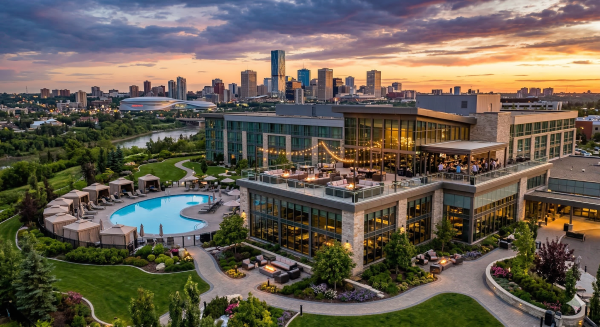
Hotels, resorts, and rec centers employ crisp, high-angle images to capture pools, courts, patios, and parking. Expansive skyline views situate the hotel within Edmonton’s river valley and downtown tech core. The property is appealing to both business and leisure travel.
Teams create image repositories for sites, booking portals, and venue pages. Multi-site chains can standardize style with batch shoots and easy cloud delivery.
-
Feature outdoor amenities, trails, and transit reach
-
Promote event setups and seasonal decor
-
Supply hero images for ads and social
Tourism
Includes aerial footage of the North Saskatchewan River and parkland as well as top attractions such as West Edmonton Mall. Cultural assets, including festivals, galleries, and museums, are enhanced by active overhead displays that broadcast across international networks. Virtual tours take you through rec centers and landmarks, captioned for accessibility.
-
Highlight trails, bridges, playgrounds, and public art
-
Create reels for civic events and festival promos
-
Support route planning with map‑style flyovers
Event Venues
Cinematic passes demonstrate stadiums, amphitheaters, and fairs, mapping entry, stages, and crowd movement. Event organizers receive overhead layouts for logistics and sponsor presentations. After the event, aerials capture attendance zones, signage, and hospitality suites to help land renewals.
-
Capture crowd density and queue management
-
Display VIP, media, and vendor footprints
-
Archive b‑roll for future campaigns
-
Enhanced marketing examples across sectors: * Real estate: roof, lot, and amenity flyovers.
-
Construction: milestone reels for lenders.
-
Hospitality: pool and courtyard hero shots.
-
Tourism: river valley and landmark trails.
-
Event venues: sponsor-ready crowd visuals.
-
Navigating Edmonton's Skies
Navigating Edmonton’s Skies | Drone photography moves fast in Edmonton, where urban growth is rapid, air traffic is on the rise and the rules are strict. Work starts with Transport Canada’s framework: basic and advanced certificates, and a Remotely Operated Certificate (ROC-A) for commercial radio use. A lot of projects require advanced certification since flights could be close to people or within controlled airspace. Crews that ship experienced pilots, mission planning software and risk checklists keep shoots punctual and regulatory.
Local Regulations
Operating rules span recreational and RPAS commercial flights, with Transport Canada as the baseline and local permits layered atop. Commercial filming frequently requires site permissions, permission from property owners, and occasionally city film permits. Safe standoff from people, buildings, and roads is absolute, and buffer distances increase with crowd size or vehicle traffic. Drone boom, 4K platforms for real estate, construction, and surveying, puts pressure on airspace deconfliction plans.
|
Topic |
Requirement |
Notes |
|---|---|---|
|
RPAS flights |
Basic/Advanced pilot cert |
Advanced needed near people/airports |
|
Commercial filming requests |
Permits + property consent |
City or site manager approval |
|
Minimum distances |
From people, buildings, roads |
Expanded for crowds/traffic |
|
ROC-A |
Required for air radios |
Typical for complex jobs |
Seasonal Challenges
Snow, wind, and cold alter flight hazard. Batteries run down more quickly in conditions below 0 degrees Celsius, with wind gusts over 8 to 12 meters per second pushing smaller airframes. Summer heat can cause thermal warnings.
Shoot at soft light close to sunrise or late day when the wind usually dies down. Noon is good for aerial mapping and tracking site progress, but shadows can obscure detail.
Edmonton’s seasons change appearance and illumination. Long summer days stretch shooting windows. Fall color reaches its peak quickly. Winter means low sun and high contrast.
-
Weather check list. * Forecast: wind (m/s), gust spread, precipitation, temperature, visibility. * Battery care: pre-warm to 15 to 25 degrees Celsius, carry spares in insulated case. * Payload: lens hoods for snow glare; ND filters for bright ice. * Airframe: prop check after ice or grit, set return-to-home height. * Operations: cold hands reduce control, use gloves, shorten flight legs. * Safety: mark landing zone, add strobes in low light.
Unique Landscapes
Edmonton combines a dense core, bridges, towers, and expansive river valley parkland. Aerial shots capture roof lines, trail grids, and the bend of the North Saskatchewan River.
Rooftops, bridges and towers rise from 50 to 120 meters, providing crisp surfaces for brand or civic projects. Golf courses, sports fields and recreation sites generate flyover demand.
Drones capture transformation nicely. Real estate listings, site logistics, and land surveys all benefit from repeat flights and matched angles. Data points are useful to see if you are making progress over a number of weeks.
Architecture, roads, and nature’s edges become transparent through aerial perspectives. With 74% of home sellers gravitating toward drone-ready agents and heavy listers utilizing them five times more, demand only continues to increase.
Elevate Your Brand Story
For Edmonton drone photography, we’re after crisp, compelling imagery that tells your brand story. They add a special perspective of locations, paths, and settings. Ground shots provide close detail. Design both as a package so each frame promotes the same story, voice, and tone across your channels.
Let professional drone photography services enhance your brand story. Start with a brief: brand values, target audience, tone, and key scenes. Plan shot lists around a theme—scale, movement, people, place. For a real estate firm, combine top-down site maps with low-altitude flyovers of key features, then supplement with ground interiors for flow. For a tourism board, follow track shots over river valleys, bridges, and plazas, then combine them with crowds on the ground. Drone photography gives you a unique point of view and when connected to a defined story arc, it is more than a “wow” shot.
Enhance Your Brand Narrative. Add hero aerials to homepages, campaign landing pages, and event recaps. Short 10 to 15 second clips work great for social ads, and you can just loop subtle orbit shots for website headers. For prints, choose broad margins at 300 or more dpi to maintain crisp edges on large sizes. Coordinate color grading and typography overlays so images read as part of a unified system. Nothing lifts your brand story like cinema, so don’t be afraid of slow reveals, parallax moves, and golden-hour light to boost recall.
Give your brand story a boost with uniform, professional quality aerial and ground photos. Set technical baselines: 4K or higher video, 20+ MP stills, steady shutter speeds, and matched white balance across cameras. Aerial shots reveal scale and context, such as stadium crowds, festival imprints, or a campus grid, while ground images capture faces and texture. Drone visuals round out your traditional photography with a complete, robust package that translates across web, print, and out-of-home.
Engage customers with storytelling that leverages the unmatched perspective of drone photography. Use arcs like “before–after,” “journey,” or “scale to detail.” Advanced technology enhances capabilities, including HDR sensors, 10-bit color, and even multispectral imaging for land or infrastructure studies. Safety and regulations are important. Confirm permits, airspace rules, pilot certifications, and site risk checks. Elevating brand stories requires creativity, tight edits, and a true grasp of what your brand stands for.
Choosing a Professional Pilot
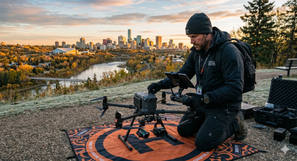
Professional Drone Work Edmonton depends on skill, permissions, and equipment. The right pilot understands how to read airspace, plan for weather, and drop clean files into your workflow.
Select experienced drone pilots with advanced drone services and licensed drone operations credentials.
Begin with license and Canada’s regulations and near airports and helis. Inquire about flight hours, particularly in tight sites such as downtown cores, rivers, and mixed-use zones. Verify experience in assignments similar to your requirements, such as roof surveys, event coverage, mapping, or broadcast. Verify liability insurance with limits appropriate to site risk and budget. Smart pilots exchange flight plans, risk logs, and a transparent safety brief. They should understand no-fly zones, visual-LOS regulations, ceiling altitudes, and approval processes and break it down in layman’s terms.
Ensure pilots use grade drones, DJI Phantom, Mavic, and other industry-leading equipment for best results.
Gear defines the aesthetic and the analytics. Consider drones like DJI Mavic 3 or Mavic 3 Pro for nimble shoots or DJI Phantom and Inspire for steadier flight and higher bit rates. Enquire about sensor size, codec, and lens specifications. One-inch or larger sensors, 10-bit color, and log profiles aid in post. For stills, 20+ MP RAW, bracketing, and low-noise glass count. For mapping or inspection, inquire about RTK GNSS, thermal or multispectral add-ons, and gimbal precision. Backups count: spare batteries, prop sets, dual controllers, and a second airframe cut risk.
Look for providers offering drone photography packages, online gallery delivery, and raw captures for flexibility.
They save you time. A good proposal outlines flight time, deliverables, number of edit rounds, and rights. Get RAW photos in DNG format and high-bitrate video in LOG or ProRes format if available, along with quick social cuts in H.264 for speedy utilization. Online gallery links and cloud transfer make reviews a breeze for distributed teams. Great teams establish deadlines, markups, and naming conventions so your editors can dive in quickly.
Partner with Andrew Shaw Photography for reliable, professional drone photography services tailored to Edmonton businesses.
Rew Shaw Photography brings licensed operations, insurance, and local airspace know-how for sites near key corridors. The team plans around wind, snow, and short light windows and shares weather holds and backup dates. Portfolios show work for real estate, construction, and land projects. Ask for references and sample RAWs to judge noise, sharpness, and color. They offer sector-ready add-ons such as orthos for builds, thermal scans for checks, or branded edits for campaigns and keep comms simple with shot lists, call sheets, and rapid proof links.
Conclusion
To differentiate yourself in Edmonton, employ crisp drone photography that reveals authentic scale, sharp lines, and accurate color. Crisp top view of a new condo. Swooping over the farm in prime light. A good shot of a rig site at dawn. Cool shots say more than fancy edits.
So that you can trust we’ll be safe, hire a licensed pilot with local airspace know-how. Request a flight plan, gear list, and raw clips. Verify wind thresholds and airtime. Dazzle short test reels with crisp 4K stills at 24 to 60 frames per second.
To get next steps, one goal, one site, one scene. Post a blip, a map pin and a date. Prepared to chart a secure, acute flight in Edmonton. Contact us for a quick consult.
Frequently Asked Questions
What makes drone photography in Edmonton valuable for brands?
These aerial images capture scale, context, and unique angles. They increase engagement, increase click-throughs, and demonstrate a location beautifully. In a city on the rise like Edmonton, drones spotlight architecture, events, and landscapes that ground photos just can’t.
Do I need permits to fly a drone in Edmonton?
Yes, the majority of commercial flights need Transport Canada compliance. Pilots require a Certificate (Basic or Advanced) and flight authorization in controlled airspace. Our professional operators manage permits, insurance, and safety plans for you.
Which Edmonton industries benefit most from drone photos?
Real estate, construction, tourism, events, and energy sectors experience robust ROI. Drone document progress, market properties, monitor assets, and produce show-stopping content that converts. They slice inspection time and trim on-site risks.
How can drone visuals improve my digital marketing?
They increase dwell time, social shares and conversions. Aerials make your ads, landing pages and maps pop! Regular drone content builds your brand authority and local search visibility.
Is drone filming safe around people and buildings?
With a certified pilot, damn straight. Pros adhere to Transport Canada regulations, keep safe distances, evaluate weather conditions, and implement geofencing. They have liability insurance and do pre-flight checklists to mitigate risk.
What should I look for when choosing a drone pilot?
Verify certification, insurance, flight hours, and portfolio with similar projects. Inquire about airspace approvals, safety measures, and deliverables. Ensure transparent pricing, a shot list, and post-production skills.
How much does professional drone photography cost in Edmonton?
Rates differ by scale, venue and licenses. Easy shoots can start from a few hundred CAD. Complicated jobs with mapping, multiple locations, or controlled airspace are priced higher. Ask for a quote that includes flight time, editing and licensing.
Looking for something else? Discover more photography services from Andrew Shaw Photography, including aerial imaging, commercial photography, and event coverage in Edmonton.
Not what you were looking for? Explore Andrew Shaw Photography’s professional drone photography and commercial imaging services across Edmonton and Alberta.
Commercial Drone Photography and Aerial Photography Services